About KC Valley Project
Updated Date: 14 Aug 2023
Koramanagala-Challaghatta (KC) valley tank-filling lift-irrigation project, commonly referred to as the KC Valley project, was conceptualised in 2018. Executed by the Karnataka State government, the project pumps secondary treated wastewater from Bengaluru city‘s five sewage treatment plants for storage in ~122 rain-fed tanks of the parched Kolar district in the sub-catchments of Dakshina Pinakini and Palar rivers. The project is executed at Rs 1,342 crores and indirectly provides irrigation water by recharging groundwater with secondary treated wastewater.

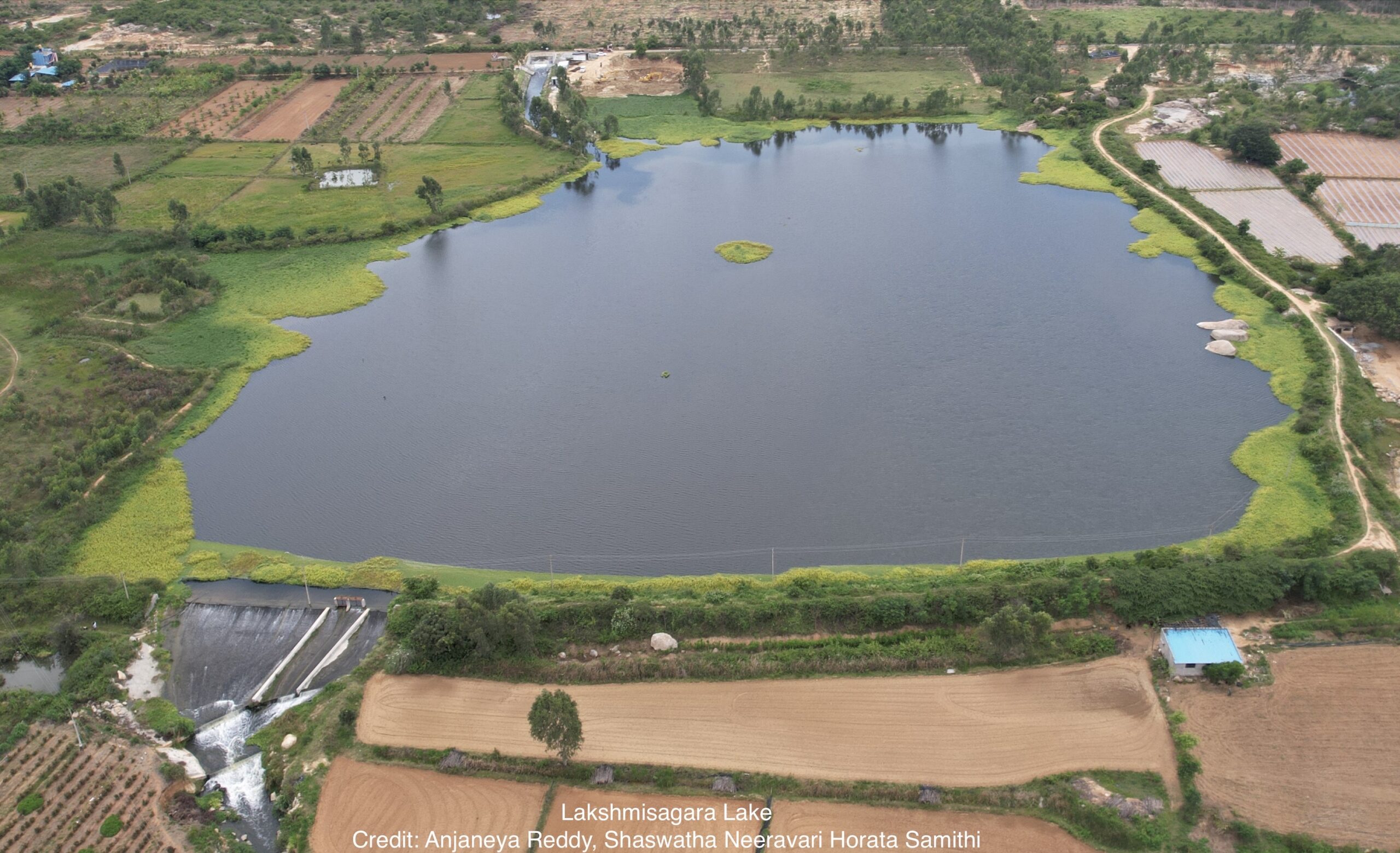
The project was brought under the public scanner when froth started emanating from Lakshmisagara Lake, the first water body in Kolar to get secondary treated wastewater under the project . Pumping of treated wastewater stopped briefly. Around the same time, concerned citizens of Kolar, under the banner of Shashwatha Neeravari Horata Samiti, filed a public interest litigation in Karnataka High Court asking for better quality treated wastewater. The court stopped pumping initially and later allowed the government to continue the project. In Jan 2020, the court directed the state government to conduct a post facto Environmental Impact analysis (EIA). The EIA is currently completed and not available in the public domain as of Aug 2023.
While the government makes the benefits abundantly clear, the risks are rarely discussed in their entirety. The nature and magnitude of the environmental and social impacts must be worked out, especially when several such wastewater projects are being modelled after this. A geospatial representation of the project in the river basin context is the first step in assessing the project’s impacts.
Click image to launch the map. Scroll down to read the narrative.
Koramangala-Challaghatta tank-filling lift irrigation project map data points:
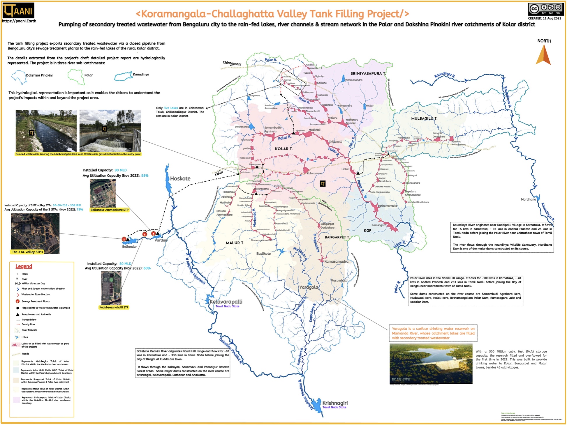
The Koramangala-Challaghatta tank-filling lift irrigation project map is constructed from the draft detailed project report obtained under Right to Information(RTI). The self-explanatory map-infographic depicts the following:
1.The lakes, rivers & streams under the project are in three catchments: Dakshina Pinakini, Palar and Kaundinya river catchments.
Palar River: (Total length ~ 380 kms)
Palar River rises in the Nandi Hill range. It flows for ~100 kms in Karnataka, ~ 48 kms in Andhra Pradesh and 233 kms in Tamil Nadu before joining the Bay of Bengal near Kaaraithittu town of Tamil Nadu. The river flows through the Koundinya Wildlife Sanctuary. Some dams constructed on the river course are Somambudi Agrahara Kere, Muduwadi Kere, Holali Kere, Bethamangalam Palar Dam, Ramasagara Lake and Kadalur Dam.
Koundinya River (Total length ~ 124 kms)
Kaundinya River originates near Doddipalli Village in Karnataka. It flows for ~5 kms in Karnataka, ~ 93 kms in Andhra Pradesh and 25 kms in Tamil Nadu before joining the Palar River near Chittathoor town of Tamil Nadu. The river flows through the Koundinya Wildlife Sanctuary. Mordhana Dam is one of the major dams constructed on its course.
Dakshina Pinakini River (Total length ~ 425 kms)
Dakshina Pinakini River originates in the Nandi Hills range. It flows for ~87 kms in Karnataka and ~ 338 Kms in Tamil Nadu before joining the Bay of Bengal at Cuddalore town. It flows through the Kalrayan, Sanamavu and Ponnaiyur Reserve Forest areas. Some major dams constructed on the river course are Krishnagiri, Kelavarapalli, Sathanur and Anaikattu.
2. The river and stream network of the catchments are shown. The flow direction of the river and stream network is also marked. Lakes marked in blue serve as landmarks; in some cases, they are downstream of wastewater-filled lakes. Yargola, a drinking water reservoir on the Markanda River, is a good example.
3. The six taluks of Kolar, whose geographic area falls in the three catchments, are shown in six different colours. ( Note: The taluk area is clipped for catchments. Also, see map legend)
4. The lakes proposed to receive wastewater under the project is in red, and the natural river and stream channels connecting the lakes are in red. Five lakes (outside of Kolar) in Chintamani Taluk of Chikkballapur district also receive KC Valley project wastewater and is represented in the map.
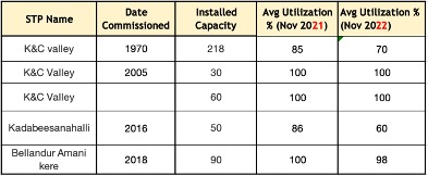
5. The five sewage treatment plants from which water is pumped are near Bellandur and Varthur lakes. The table below gives additional details on the plants. Note: Karnataka government calculated wastewater availability for pumping based on installed capacity, which is 448 MLD. However, the actual wastewater available for pumping varies monthly based on how much sewage flows into the treatment plant. The utilisation % shows the actual use of the total installed treatment capacity.

6. The pumped secondary treated wastewater from the five sewage treatment plants travels roughly 53 km via closed pipes to Lakshmisagara Lake, shown on the map as a black arrow. After that, the wastewater flows primarily in the natural stream network to reach the next lake (drainage shown in red). Where natural flow is not possible, water is pumped to the nearest ridge point and from there on, wastewater flows in the natural stream channels. In the case of Somambudhi Agrahara, Muduvadi, Chillapalli, Holali, Bethamangala and Ramasagara, the wastewater flows in the main Palar river channel. The black arrows indicate pumped flow, while the red arrows indicate gravity flow.
Datasources:
- Complete drainage and sub-catchments of the river are derived from Indiawris.
- The project details are obtained from draft detailed project report obtained under Right To Information (RTI).
- STP data Utilization numbers are taken from the Monthly Progress Report received from the state of Karnataka in the NGT Matter OA No. 673 of 2018.

RIVER BASIN

DAMS & FLOW

POLLUTION

GROUNDWATER

STRAWS

BIODIVERSITY

RAINFALL FLOODS & DROUGHT

RESTORATION


