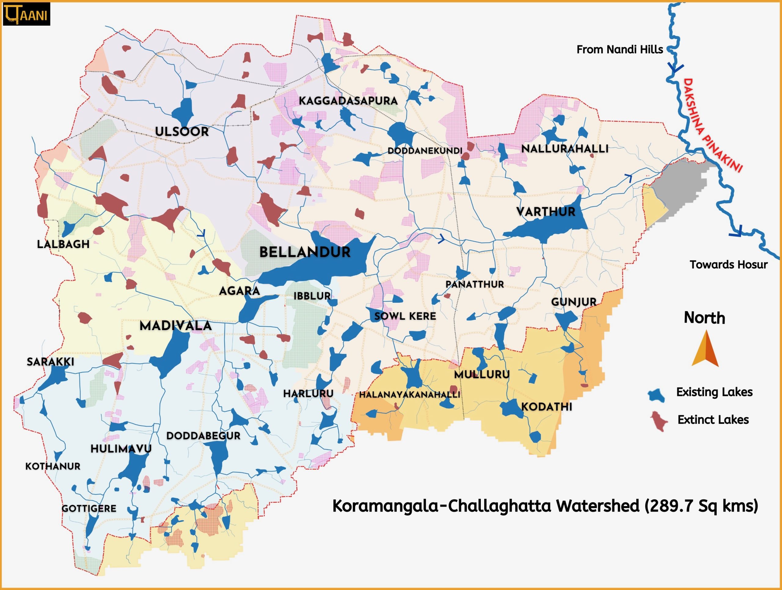
The map shows the significantly altered urban hydrology, including the famed interconnected lake system for lakes > 3 acres. The lake area, lake custodian, and current state of lake development are given. Lakes ( >3 acres) driven to extinction are identified, and their current land use recorded. Stressors such as Industrial Areas, Quarries & Sewage Treatment Plants & Major Roads are marked.
The narrative below gives insights and resources that activists can use. The narrative also takes the KC watershed and Dakshina Pinakini river discourse from generalities to specifics backed by ample evidence.
Frequently Asked Questions(FAQs) are at the bottom of the page. Please refer to them and read the narrative before writing to us.
Click Image to load the map. Scroll down to read the narrative & FAQs. The map will be updated without prior notice. Check the Updated date and Version number on the map itself.
About Koramangala-Challaghatta (KC) Watershed:
The shape of the map is that of the KC watershed. Multinational technology companies like Microsoft, Amazon, Wipro, Infosys, Accenture, Capgemini, Bosch, Cisco, and many more have major offices here. KC watershed is one of the fastest growing areas of Bengaluru with high population density.
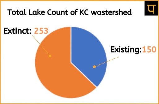
The total number of lake waterbodies of all sizes, of both existing and extinct lakes are shown in the image. The map identifies lakes >3 acres. Bengaluru was once known as the land of thousand lakes. However, the rate at which the lakes have disappeared and are disappearing, Bengaluru may as well be known as the land of extinct lakes.
The distribution of lakes by size is captured later in the narrative.
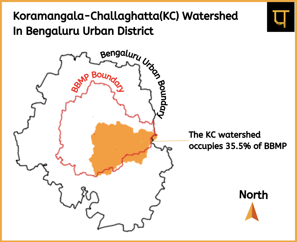
The images below shows the administrative spread of the watershed.
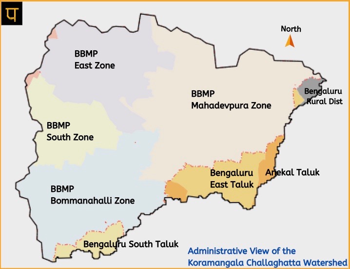
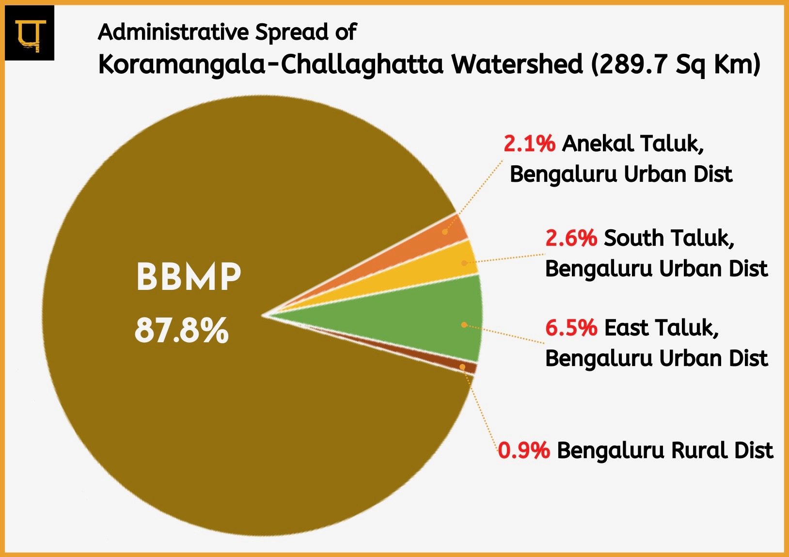
The KC watershed forms 35.5% of Bengaluru City Municipality – Bruhat Bengaluru Mahanagara Palike (BBMP) as shown in the image below.
The 35.5% is completely concretized. The new Bengaluru city municipality- Bruhat Bengaluru Mahanagara Palike (BBMP) boundary, per the Govt of Karnataka notification dated 14-17-2022, was obtained from OpenCity. The area of the BBMP boundary based on the GIS package received from Open city is 716 sq.kms.
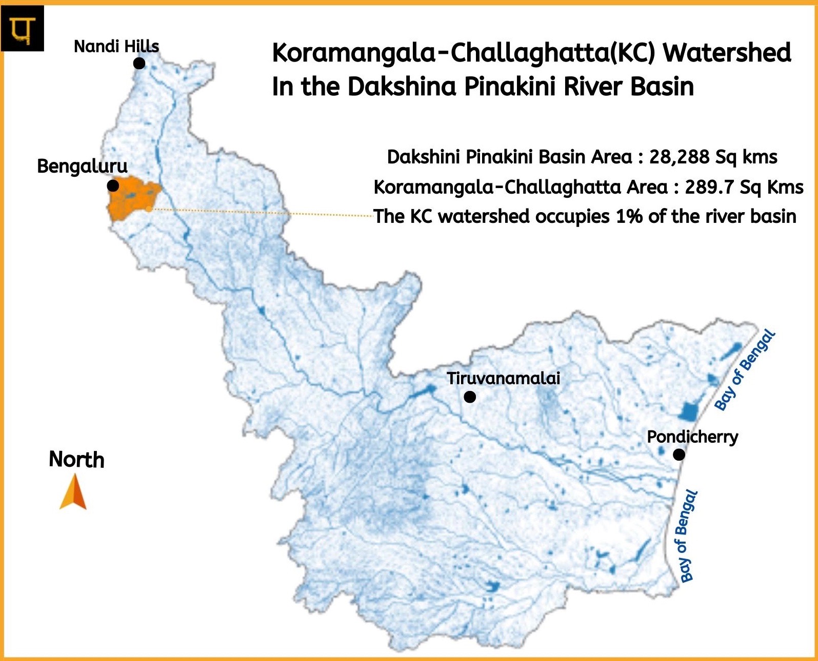
The KC watershed forms 1% of the larger Dakshina Pinakini River Basin as shown in the image below. Though the watershed only forms 1% of the larger Dakshina Pinakini River Basin, it is the biggest polluter of the river. The waste: Industrial effluents, raw sewage, and solid waste flow into the river, asphyxiating the Dakshina Pinakini river.
Altered Man-Made Hydrology & its data sources:
Hydrology, Rajakaluves, Storm Water Drains, Streams & Drainage are all the same. These are the network of streams that eventually take monsoon run-off to the Dakshina Pinakini river. However, because of Urbanization, Industrialization, and Concretization, natural drainage and topography have changed significantly. Thus, there is no natural hydrology, only man-made hydrology .
A definitive data source of man-made hydrology does not exist, even for government planning and decision-making, esp. for flood prevention and mitigation (Urban flooding is extremely severe and quite common in this watershed). This deficiency was flagged by the Comptroller Auditor General (CAG) of India in its 2021 report ‘Performance audit of management of storm water in Bengaluru Urban area’.
Although not definitive, two government sources exist. Bengaluru Development Authority’s (BDA’s) Revised Master Plan (RMP) for Bengaluru (2031) and BBMP’s Major Storm Water (MSWD) drain map (Aug 2014). The RMP’s 2030-proposed land use map and 2015-existing land use map data have been combined, analyzed, and harmonized with BBMP’s MSWD to form the base drainage layer.
The BDA’s 2030-proposed land use map is integrated to show how the BDA plans to upgrade the existing drainage in the context of lakes and rivers. The proposed drainage is similar to BBMP’s MSWD(Aug 2014) and has the same missing lake connections – Halnayakanahalli, Junasandra, Pattandur Agrahara Devarakere & Byrasandra.
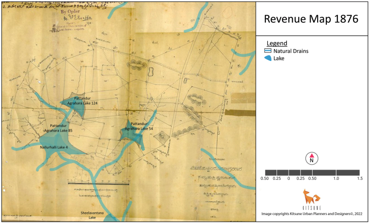
The connectivity of Pattandur Agrahara lake was updated on the map after the citizens alerted us by sending the revenue map data, as shown in the image. The connectivity of Halynayakanahalli lake on the map is again based on citizen reporting. Byrasandra lake connectivity is based on the Cadastral map. Lack of connectivity and extremely narrow drain (if it exists) is one of the many reasons the areas around these lakes flood.
Additionally, the drainage for areas marked as industrial is non-existent. We augmented some of these drainages by referring to Cadastral maps ( survey done in the 1900s) & Survey of India Toposheets (survey done in the 1970s).
Lakes and its data sources:
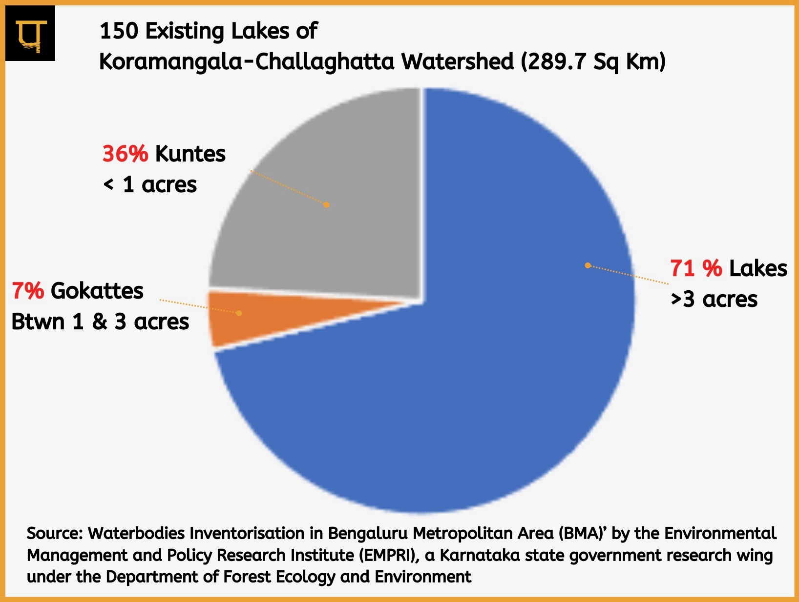
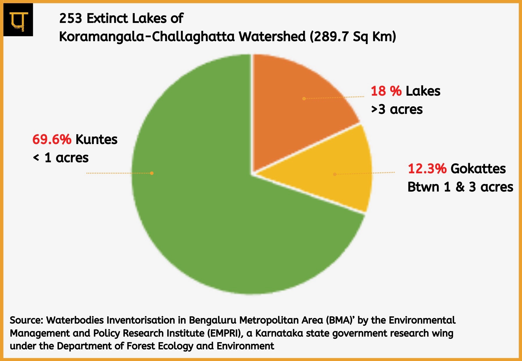
The map shows extinct lakes (> 3 acres), existing lakes(> 3 acres), and their interconnectivity.The pie chart shows the division of existing lakes by size. 71% of the Lakes are > 3 acres and are marked on the map.
There are two sources of existing lake data for the BBMP area. One is on the BBMP website, and the other is ‘Waterbodies Inventorisation in Bengaluru Metropolitan Area (BMA)’ done by the Environmental Management and Policy Research Institute(EMPRI), a Karnataka state government research wing under the Department of Forest Ecology and Environment.
The data from EMPRI was validated with cadastral maps, Survey of India Toposheets (D43R12_57G12, D43X9_57H9), BDA’s RMP (2031), BBMP’s MSWD (Aug 2014), Koliwad Committee Report on encroachments and European Commission’s Global Surface Water Explorer. We found EMPRI data, prepared by referring to the Department of Survey Settlement and Land Records (SSLR), to be reliable and comprehensive. The area of the lake recorded on the map is from EMPRI.
EMPRI is an excellent reference for all stakeholders. It has five volumes.
- Volume-I
- Volume – II (Part 1) Bengaluru North Taluk
- Volume-II (Part 2) Bengaluru East Taluk
- Volume – II (Part 3) Anekal Taluk
- Volume-II (Part 4) Bengaluru South Taluk
About ‘The Great Urban Lake Extinction’ and its contribution to urban floods:
Extinct lakes are lakes that have been converted for other land uses. EMPRI calls them disused. We call them ‘Extinct,’ a more appropriate term. Extinct lakes are included in the map to show how their extinction has altered the flow of water and has played a role in aiding & exacerbating urban floods in the watershed.
The pie chart shows a significant number of smaller lakes have gone extinct. The numbers indicate that lakes <3 Acres face a disproportionately higher risk of extinction when compared to lakes >3 acres. A whopping 89.9% of the lakes of size < 3 acres have gone extinct.
It is logical to repurpose these smaller waterbodies as recharge structures. As can be seen in the pie chart above, about 43% of existing lakes are <3 acres. We must prioritize these areas and repurpose them as legally protected recharge structures before we lose them. Treated wastewater from sewage treatment plants can be channeled here for recharge. It could also be part of the ‘A Million Recharge Well‘ project that was started by the voluntary citizen network Friends of Lakes (FOL) and Biome Environment Trust. Similar to the citizen’s MOU with BBMP on lakes, an MOU with the govt to build recharge structures can be explored.
The extinct lakes data is primarily sourced from EMPRI’s disused lakes list. One exception to EMPRI’s disused list is Koramangala Lake. National Dairy Research Institute occupies 80 of the 99-acre lake, and because of this 80% encroachment, we are classifying Koramangala lake as extinct.
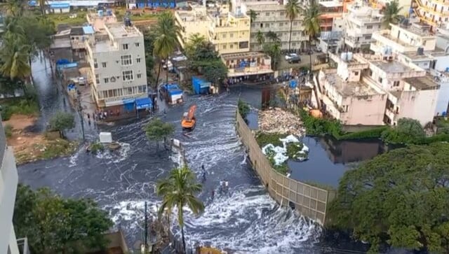
It is obvious from the map that upstream of Bellandur Lake on the Koramangala Stream and Challaghatta stream is where much of the lake extinction has occurred. The extinct lakebeds, now impervious, coupled with the concretization of stream beds, not to mention the completely built-up catchment, all dramatically increases the speed at which water moves. This context helps us better understand the overtopping of Bellandur lake during the recent spate of unprecedented rains. A considerable volume of water sped through the concrete jungle towards Bellandur Lake, overtopping it and severely flooding the downstream communities.
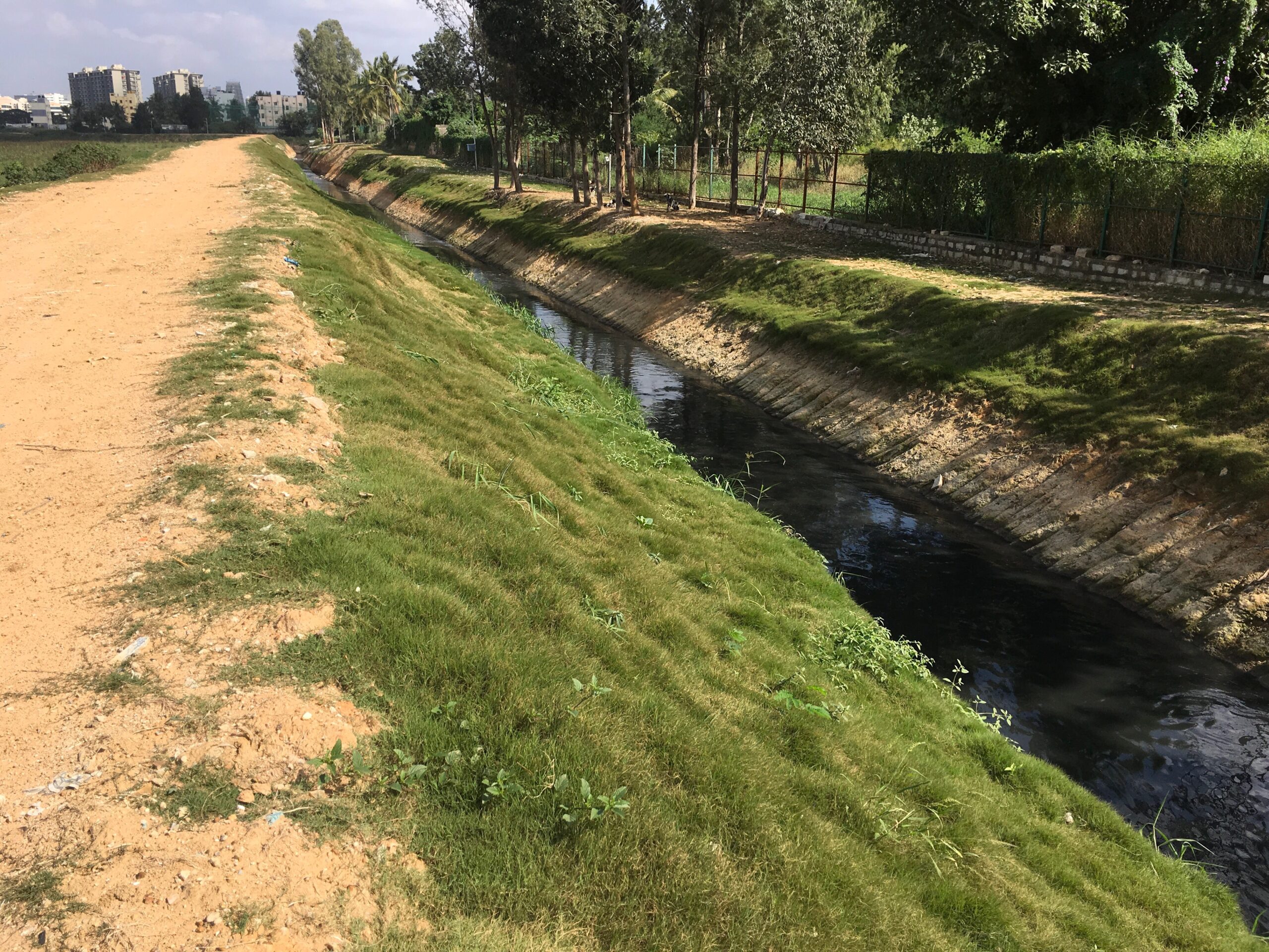
Another flood-related insight from the map pertains to Ulsoor lake. The 100-acre Ulsoor lake is the only non-extinct lake in Challaghatta Catchment, baring the small Balyappanahalli Lake. This sole permeable waterbody, unfortunately, is isolated from the interconnected lake system because of the deliberately engineered bypass.
The inlet stream channel that brings water to the lake is engineered to bypass the lake and connect directly with the stream channel downstream of the lake. Bypass is created to prevent the non-biodegradable undiluted raw wastewater (Industrial effluents, sewage, and disintegrating solid waste), the de-facto 365 days 24/7 flow in the concretized streambeds, from entering the lake and polluting it. Because of the bypass, the 100-acre lake is useless for harnessing flood waters. Besides, Ulsoor lake’s source of water (or wastewater) is the sewage treatment plant located next to the lake, as depicted in the map. The lake is full of secondary treated wastewater all around the year; thus, there is just no space for flood waters.
It is a critical mass of these micro-level changes (including the box-type concretization of stormwater drains with flow-hampering sharp straight angle bends) made over a period of time to the drastically altered urban hydrology that exacerbates urban floods in the watershed.
About Lake Custodianship:
The lakes in the watershed are under the jurisdiction of different authorities: BBMP, BDA, Zilla Panchayat, Minor Irrigation, and the Horticulture department.
As per government order (Sept 2016 & Dec 2019), lakes in the BBMP area are under BBMP custody (CAG Report). An exception to this: Bellandur and Varthur lakes which are in BDA custody, and the Lal Bagh lake inside Lalbagh Botanical Gardens, is under the horticulture department.
Then there are orphan lakes. Orphan lakes fall in the BBMP jurisdiction but are unacknowledged by BBMP. The majority of the <1 acre lakes are orphaned. Some of the >1 acre lakes, orphaned are below:
- 3 Acres 16 Guntas. Chandrasekharapura Govt lake
- 1 Acres 1 Gunta Begur kunte
- 6 Acres 3 Guntas Panatthur Kere
- 1 Acres Gunjuru Kunte
- Sadanandanagara (K R Puram Hobli, Bendeganahalli Village, Survey no 34)
- Balyappanahalli Lake (above Ulsoor)
Zilla Panchayat (including Taluk Panchayat and Gram Panchayat) has jurisdiction over lakes outside BBMP. An exception to this: Halnayakanahalli Lake and Kothanur Lake. Both are under the Minor Irrigation Department as indicated in the Map.
Lake Development BBMP-Style, and its connection to the foetus:
Lakes developed by Bruhat Bengaluru Mahanagara Palike (BBMP) are identified on the map. Owing to the pressure from citizens to clean up polluted lakes, BBMP started ‘developing’ select lakes ignoring the lake interconnectivity, as can be ascertained in the map. Hydrologically speaking, lakes upstream in the cascading series must be selected first. If the upstream lake’s pollution is tackled, the downstream lakes will receive significantly less pollution load. It is a better solution for the whole watershed and the Dakshina Pinakini river. But BBMP-style development (and BDA style as well) chooses lakes regardless of interconnectivity.
And this leads to the engineered bypass discussed earlier – pushing the pollution problem downstream instead of addressing it. The adverse outcomes of pollution pushing to Dakshina Pinakini river are not a concern to BBMP, as Dakshina Pinakini river, which takes all the brunt, is outside its jurisdiction (See map). So, it becomes Pollution Control Board’s (PCB) concern. More accurately, PCB’s legal mandate. But, despite the legal mandate and autonomy of PCB, the bureaucracy is incompetent, lacks resources by design, and, most importantly, unsympathetic.
Like the bureaucracies, the citizens cannot afford to ignore this. The toxic wastewater from the KC watershed is widely used to irrigate vegetable & fodder fields downstream.
So, the toxic non-biodegradable pollutants from the wastewater enter the soil and make their way into vegetables, milk, eggs, and meat, which are then dumped into Bengaluru’s vegetable supply. From here, the pollutants travel to our dinner plates and happily settle in our bodies. These chemicals (e.g., Dioxin, Heavy metals like Lead, Cadmium, etc.) present in copious amounts in the wastewater are so toxic that they penetrate the placental barrier and settle in the tiny bodies of the yet-to-be-born. This means that our children are born pre-polluted—a chilling fact. Intergenerational human pollution with dire consequences, happening silently behind the scenes.
About Industrial Pressures in the watershed:
An attempt has been made to mark areas where major industrial activity exists. However, this does not mean industrial activity only happens in the marked areas. On the contrary, it is scattered throughout the catchment. The industrial representation is harmonized data from Karnataka Industrial Areas Development Board (KIADB), Open Street Map, and BDA RMP – 2031’s 2015 existing Land use map. The areas marked are indicative only. Some drainage has been recorded by referring to the Cadastral map.
The representation gives a quick view of other polluters besides residential settlements. This representation is significant in putting to rest the dominant & one-sided narrative of sewage pollution by residential settlements, actively propelled by Karnataka State Pollution Control Board (KSPCB).
Industries pollute rampantly. They release small quantities of toxic non-biodegradable chemicals into the drains surreptitiously. The chemicals are transported far from the point of origin by the humungous quantities of sewage flowing in the drains. Therefore, it is important to talk about industrial pollution if we are serious about addressing it.
About Quarries and how Bellandur lake’s toxic sludge comes full circle:
The founders of Paani.Earth, who are also trustees of Bangalore Environment Trust (BET), have worked extensively with the government and the judiciary on BDA’s Bellandur lake rejuvenation. The work is well documented on BET’s website.
One particular lake rejuvenation action of the BDA that BET vehemently opposed was desilting. The dug-up sludge, both expensive (Rs 131 crores allocated for desilting, which accounted for 77% of the lake rejuvenation cost) and hazardous with toxic and non-biodegradable heavy metals, was destined for quarries around Bangalore. The unscientific dumping in the quarries would leach heavy metals into the groundwater contaminating the drinking water.
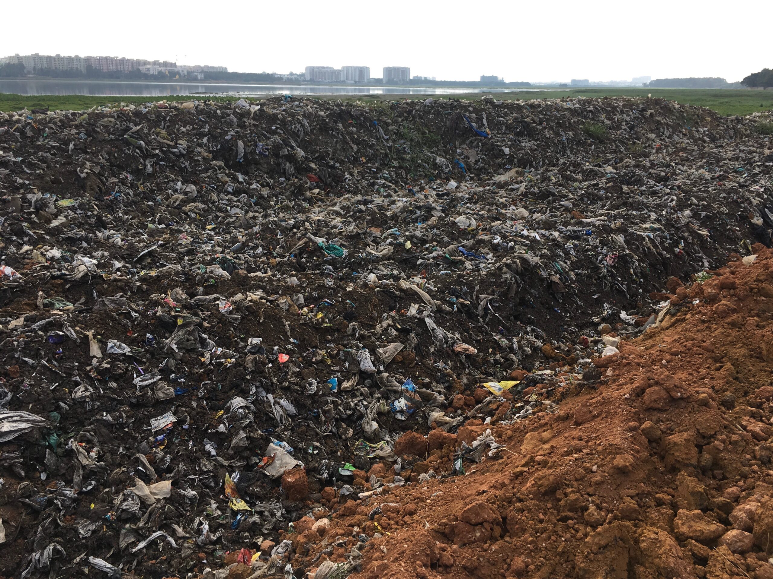
Despite our logical reasoning and vehement protest, BDA went ahead with de-siltation and dumped the toxic sludge into Vittasandra and Mylasandra quarries. During this watershed mapping and analysis exercise of quarries, we found that the Vittasandra and Mylasandra quarries are located upstream of Bellandur Lake in Bengaluru South Taluk. As seen in the map, the quarry drainage flows towards Begur lake and back to Bellandur Lake. Therefore, there is a very high likelihood that the heavy metals dumped into the quarries might find their way back to Bellandur lake, subsequently to the Dakshina Pinakini river and our dinner plates.
Frequently Asked Questions:
- Why do the lake shapes not match the lake shape on revenue’s survey records?
The lake shapes are obtained from Karnataka State Remote Sensing Application Centre’s (KSRSAC) Karnataka Geographic Information System (K-GIS). KSRSAC has created the shapes by remote sensing, meaning the shapes are drawn using satellite images based on water spread. As K-GIS dataset is widely used, the same shapes get repeated across different maps.
These shapes only serve the purpose of indicating the presence of the lake on the map and is not usable to determine lake boundary.
- Can we use the map in judicial matters?
The map-data can be used in judicial matters to give a macro-level view to the court before diving deep into your particular issue. It will aid the court in understanding the magnitude of the case. As part of Bangalore Environment trust, we have used hand-drawn maps as part of our Public Interest Litigations (PIL). We also know of other PILs, where our hand-drawn map is used.
We have made every effort to ensure the data is accurate and have published all the references used. However, to protect ourselves, we must say: Any use of the map-data is at your own risk and that Paani.Earth as the creator of map-data, is not liable for any adverse outcomes.
Updated Date: 15 Dec 2022
——
Paani.Earth is licensed under a Creative Commons Attribution-NonCommercial-ShareAlike 4.0 International License

RIVERS

LAKES

POLLUTION

GROUNDWATER

DRINKING WATER

BIODIVERSITY

RAINFALL FLOODS & DROUGHT

