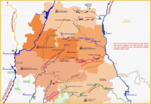
Rivers of Bengaluru:Vrishabhavathi, Arkavathi, Dakshina Pinakini, Chinnar, Suvarnamukhi, Cauvery and Netravathi.
Rivers of Bengaluru map-infographic is a simple spatial representation of rivers of concern to Bengaluru and how we connect with them. The rivers of concern are not limited to just the rivers that flow in the district, but also includes Cauvery and Netravathi from which we draw our drinking water. Since surface water flowing in the river and the ground water is a single resource, the state of ground water is also represented.
The map has Bengaluru district and its 5 taluks including the BBMP area at the center, with rivers flowing in and around it. The datapoints given are: river origins, river lengths, elevation, groundwater status, past and present drinking water lifelines of Bengaluru, downward movement of waste and upward movement of water, besides hydrology and administrative boundaries.
The objective is to bring perspective on the use and abuse of rivers. Waste flows in natural river corridors without exception and water in man-made pipelines. Both devoid of life, flow in opposite directions. The situation is especially stark for the rivers passing through the district: Vrishabhavathi, Arkavathi, Dakshina Pinakini, Chinnar and, Suvarnamukhi, as they are already converted into drains. Cauvery, the current drinking water source, is not spared either. Heavily polluted and altered, the river is in a dire state.
Mostly forgotten in all this chaos, is wildlife. They need water just like us.
We are not writing long narratives with the map, allowing citizens to make their own observations. The map shows much more to a discerning eye. Tell us what else you see in the map.
ABOUT THE MAP:
Like all our maps, this is built to scale using QGIS , a Free and Open-Source Geographic Information System. Geo-spatial data on administrative and forest boundaries is from Karnataka State Remote Sensing Application Centre’s (KSRSAC) Karnataka Geographic Information System (K-GIS). We have also referred Survey of India Toposheets, Indiawris.gov.in, bhuvan.nrsc.gov.in along with google earth engine’s JRC Global Surface Water Mapping Layers are used to validate hydrology.
While most datapoints are from government reports, the rainfall and population are from Google Earth Engine datasets. Most important is our on-the-ground dialogues with river bank communities and government, that allowed us to understand the nature and magnitude of human activities first hand, so as to build a narrative that reflects the state of affairs on the ground.
All datapoints are referenced in the image pdf.
——–
Paani.Earth is licensed under a Creative Commons Attribution-NonCommercial-ShareAlike 4.0 International License

RIVERS

LAKES

POLLUTION

GROUNDWATER

DRINKING WATER

BIODIVERSITY

RAINFALL FLOODS & DROUGHT

