Vrishabhavathi river is most talked-about among the citizens, media, academia, private researchers, and various government bodies for its alarming levels of toxic pollution. There are many public interest litigations in high court to get the river cleaned up. Despite this, a basic river basin map does not exist. We have produced the Vrishabhavathi river map to fill this gap. Map is interactive. Clicking the lake names on the map will connect to the lake location on google earth. Click image to launch the map.
Vrishabhavathi river map is a colorful and slightly complex map , that plots a wide range of human activities affecting the Vrishabhavathi river: Industrial clusters, Sewage treatment plants, Industrial effluent treatment plants, Hazardous waste Landfills, Urban centers, Open-pit quarries, Hydropower plants etc. Additionally, it also provides details of major lakes in the basin along with drainage. Scroll down to see the list of 25 useful data points given on the map.
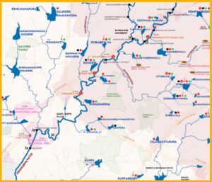
The river basin map gives the following 25 useful data points:
Abbreviations are at the bottom
1. The 69-km river journey from Sankey tank to the Vrishabhavathi confluence with the Arkavathi river is mapped. River kilometers are marked. So is elevation. Vrishabhavathi elevation drop from origin to confluence can be seen here.
2. Complete drainage of the river is drawn from Indiawris Some are highlighted in blue, while the rest are in grey. The blue drainage represents how major lakes are connected to the river. In some cases, it also shows connectivity to human stressors like quarries, industries, etc. This drainage color coordination makes the map readable.
3. Byramangala dam and Suvarnamuki anicut are the two dams built on the river for irrigation and are marked. Since the river flows 24/7 with toxic wastewater, both the dams store wastewater used for irrigation. Byramangala dam’s wastewater irrigated area is roughly 3954 (1) acres, while the Suvarnamuki anicut wastewater irrigated area is not known.
4. Administrative boundaries obtained from KSRSAC are plotted. The river basin is spread across two districts – Bengaluru Urban and Ramanagara. Bengaluru Urban occupies 58% of the river catchment, while Ramanagara occupies the rest of 42%.
5. BBMP, Bengaluru Urban district’s city municipality, is marked as a shaded area inside Bengaluru Urban district. The completely concretized BBMP area occupies 23% of the total river basin. This 23% is the largest source of sewage and solid waste in the river.
6. Six (6) large secondary sewage treatments maintained by BWSSB are plotted. Vrishabhavathi Valley old (120 MLD), Vrishabhavathi Valley new (150 MLD), Mailasandra (75 MLD), Kengeri (60 MLD) Doddabele (40 MLD) and Doddabele (20 MLD) (2).
7. The Vrishabhavathi Valley Tertiary Treatment Plant (60 MLD) is the only tertiary sewage treatment plant in the basin. It is maintained by BWSSB and is shown on the map (2).
8. Seven (7) secondary sewage treatment plants maintained by BBMP, typically built next to the lakes, are marked. Malathahalli (5 MLD), Ullal (0.3 MLD), Herohalli (1.5 MLD), Deepanjalinagara (0.6 MLD), Kempambudhi (1 MLD),Uttarahalli (0.5 MLD) and Dorekere (1 MLD) (2).
9. Four industrial areas in the Vrishabhavathi river basin are marked: Peenya, Kumbalgodu, Bidadi, and Harohalli. Peenya industrial area is maintained by BBMP. The rest are maintained by KIADB. Some industrial clusters near Bapujinagara and Nayandhahalli are also plotted (3).
10.The river basin hosts two hazardous waste landfills operated privately by Mother Earth Environ Tech Pvt Ltd and regulated by KSPCB. Both the landfills, are in Harohalli Industrial area. They are 4 (closed) and 9 (new) acres respectively (4)(5).
11. The two common industrial effluent treatment plants operated privately by Pai and Pai Chemicals (I) Pvt LTD and regulated by KSPCB, are marked in Kumbalgodu industrial area (4).
12. The two-megawatt Hydro-electric plant operated by Rising Sun Hydro Private Ltd is identified and marked at 62.5 river-kilometer. Karnataka Renewable Energy Development Ltd is the regulating govt agency (6).
13.Open-pit quarries are identified using Google Earth Engine, Google Earth imagery, and Toposheets [ D43X9 (57H/9), D43X6 (57H/6), D43X5 (57H/5) ]. The map shows the waterbodies affected by quarries. Department of Mines and Geology is responsible for mining leases whereas KSPCB is responsible for pollution.
14. KSPCB monitors the main Vrishabhavathi river stem at 15 locations. It also monitors 9 locations on the Nagarbhavi stream. Furthermore, it monitors 15 lakes. All are marked as small black squares. Some river kilometers markings are aligned with the monitoring locations (7).
15.The groundwater status, as classified by the Central Ground Water Board is documented. Bengaluru district’s taluks in the basin are overexploited, while Ramnagara district’s taluks in the basin, are critical. The board assesses the stage of groundwater development/extraction by taluks as Safe, Semi-Critical, Critical, and Overexploited (OE) (8).
16. Reserve forests, State forests, Wildlife sanctuaries, and National parks are marked in green lines as per Survey of India toposheets [D43X9 (57H/9), D43X6 (57H/6), D43X5 (57H/5) ]. They are maintained by Karnataka Forest Department.
17. Three major roads: Mysore road, Kanakapura road, and NICE, are marked.
18. 2015 basin population of 4.02 million is a datapoint from NASA’s gridded population dataset and the 40-year Avg rainfall of 1024 mm is from CHIRPS.
Basin Lakes Datapoints:
19. Five hundred and thirty-one (531) lakes are mapped as per Survey of India toposheets [ D43X9 (57H/9), D43X6 (57H/6), D43X5 (57H/5) ]. All the 531 lakes are represented as polygons in light grey (background) and blue (highlighted). Few lakes not represented in the toposheets but marked in the cadastral map are also included. Out of 531 lakes, 58 lakes are in the BBMP area as identified on the map.
20. Eighteen (18) lakes are owned by Minor Irrigation Department. Data on lake area ( in acres) and lake storage capacity (in million cubic feet), as obtained by us via RTI, are given on the map.
21.Typically, all lakes in the BBMP area are maintained by BBMP. The lakes outside of the BBMP area are maintained by Bengaluru Urban Zilla Panchayat, although there are exceptions. For instance, Komghatta lake outside BBMP area is maintained by BDA.
22.Almost all the lakes in Bengaluru urban district are cesspools. The process of government restoration with civil engineering works is called development. Lakes thus developed are identified as developed lakes. These are marked with a green dot on top of the lake name. Some lakes in various stages of development also have the green dot (9) (10) (11) (12) (13) (14)(15).
23. Fish kills incidences of lakes reported in the media, are marked with a red fish-bone icon. The Kodihalli and Chowkahalli lake fish kills were reported to us and we have lost the pictures of fish kill that was sent to us by the villagers. Nonetheless, they are marked (16) (17) (18) (19) (20) (21) (22) (23) (24) (25) .
24.Encroached lakes are marked with a red dot on the lake name. The data is based on the report ‘Inventorization of Water Bodies in Bengaluru Metropolitan area’ and the Koliwad Committee report. The river channel and natural drainage are also encroached on and could not be represented (26) (27) .
25. Lakes have gone extinct, especially in the BBMP area. We have identified 12 such extinct lakes whose area is greater than 10 acres, based on the report ‘Inventorization of Water Bodies in Bengaluru Metropolitan area’ and the Koliwad Committee report. Existing use of the extinct lakes are documented on the map. Disused lakes in the report ‘’Inventorization of Water Bodies in Bengaluru Metropolitan area’ are called extinct lakes. Lakes with 90% or more encroached area, are also classified as extinct (26) (27) .
ABBREVIATIONS:
- BBMP : Bruhat Bengaluru Mahanagara Palike
- BWSSB: Bangalore Water Supply and Sewerage Board
- BDA: Bangalore Development Authority
- KSPCB: Karnataka State Pollution Control Board
- KIADB : Karnataka Industrial Areas Development Board
- KSRSAC: Karnataka State Remote Sensing Applications Centre
- MLD: Million Litres Per Day
- RTI : Right to Information

RIVER BASIN

DAMS & FLOW

POLLUTION

GROUNDWATER

STRAWS

BIODIVERSITY

RAINFALL FLOODS & DROUGHT

RESTORATION

