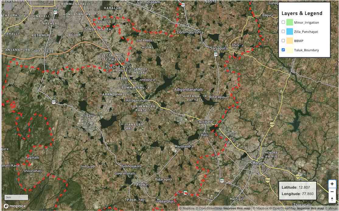
Arkavathi River Interactive Map
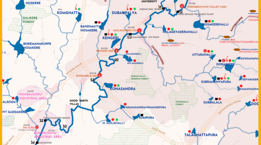
This interactive map shows the impact of high pollution levels on life along the Arkavathi River. It integrates primary monitoring data from Paani with information from government, research institutions, and citizen groups to provide a comprehensive view of the river’s pollution.The results highlight the pollutants of concern that are likely byproducts of industry, agriculture, and urbanization in the surrounding area.
This living map will be updated as new data becomes available through primary research and secondary sources. Explore the monitoring points in the map below to learn more about pollution in the Arkavathi and how these pollutants can harm human and ecosystem health. Please click on the ‘Info’ button in the left corner of the map below to understand the map layers and how to interact with the map. This map is web-optimized and the best viewing experience is on a desktop browser.The current version of this map is web-optimized. Special thanks to our intern Pranith for helping with the initial mapbox code setup
Why measure Arkavathi River pollution?
If we can identify, monitor, and stop the sources of pollution in the Arkavathi, the river could once again become a safe source of water for Bangalore and surrounding areas.
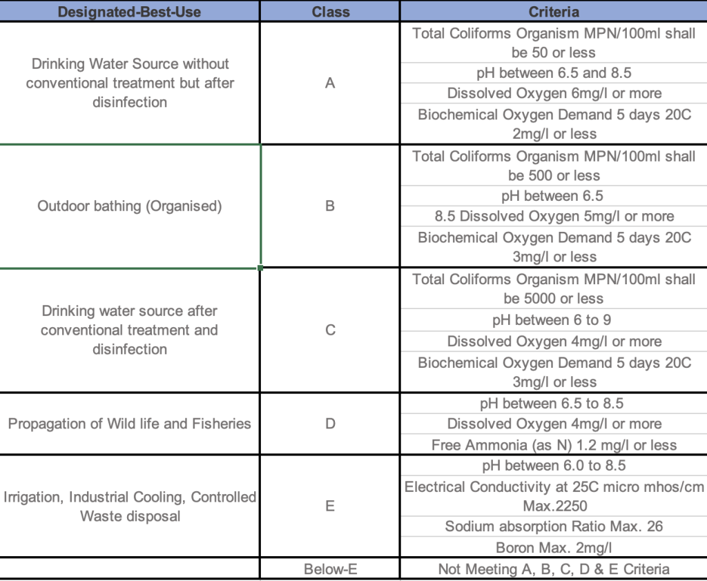
Continuous monitoring is necessary to prevent harm to human and ecosystem health from exposure to pollutants. While the National Water Quality Monitoring Programme (NWMP) monitors locations on the river, data available in the public domain (also available here) are fairly limited to a maximum of eight criteria used to determine the Designated-Best-Use of water per Central Pollution Control Board (CPCB) guidelines. For comparison, in the United States, the National Recommended Water Quality Criteria for Human Health recommends testing over 110 pollutants ranging from toxic chemicals to naturally occurring elements like zinc.
The map and its associated data go beyond the scope of the National Water Quality Monitoring Programme (NWMP), to show how harmful pollutants affect the Arkavathi River and the people and wildlife depending on it. By performing testing of water and surface sediment samples, Paani confirmed the presence of harmful substances not covered by the NWMP. This map starts a dialogue on the need for more comprehensive monitoring of harmful pollutants along the Arkavathi.
Concerning Pollutants in the Arkavathi
Drains and discharge from agricultural, industrial, and populated areas all contribute to pollution in the Arkavathi. Even in sections of the river clean in appearance, Paani sampling demonstrated the presence of pesticides, polycyclic aromatic hydrocarbons (PAHs), and organic substances that can harm wildlife in high doses that are not regulated in water in India .River flow measurement confirms that the majority of polluted water is untreated. While the levels of pollution varied across different test sites, the following substances had consistently high levels across sites:
- Chromium and Hexavalent Chromium which are known byproducts of industry (including chrome plating) that can cause cancer
- High levels of phosphorus which can indicate a eutrophic environment with algae blooms and limited sunlight
- Mercury-levels that may be harmful to aquatic life
- PAHs like Dibenz[a,h]anthracene and Benzylbutylphthalate that are produced from fuel burning
To learn more about pollution at each site, click on the different monitoring locations in the interactive map.
It is important to note that safe pollutant levels for water and sediment are constantly updated based on scientific advances. While one pollutant may be within acceptable limits, the combined effects of multiple harmful chemicals at lower concentrations may not be fully considered in the prescribed safe levels. Continuous testing and monitoring are essential to understanding the full impact of pollution in the Arkavathi river basin.
What happens when water doesn't meet a Designated-Best-Use?
The CPCB guidelines measured by the NWMP provide a limited “report card” on water quality. This report card does not trigger any regulatory action. This means that lower quality water may be used for a higher best use unless there is intervention from the National Green Tribunal (NGT) or another entity.
The NWMP has the intent to identify pollution sources and mitigate them as per the CPCB Guidelines on Water Quality Monitoring 2017, but the current implementation falls short of achieving that goal.
The full list of criteria for Designated-Best-Use is less comprehensive than similar standards in other countries. India’s earlier, more comprehensive surface water quality standards (IS 2296 : 1982) were recalled. Furthermore, the NWMP does not measure sediment pollution, which can show a historical record of chemicals and pollutants in an ecosystem. Both Canada and the United States publish criteria for soil and water health.
How was this information collected?
This map demonstrates geospatial information about the Arkavathi River and surrounding areas prepared by Paani. Paani sourced layers from publicly available documents of the Central Water Commission, Central Pollution Control Board and data obtained through RTI from KSPCB, India WRIS, and KGIS. Paani prepared the map using QGIS.
This map and associated infographics also include pollution data that were collected by Paani in collaboration with the International Centre for Clean Water (ICCW). The data for water and sediment quality were collected following the procedures outlined in IS 17614 standards (Part 6 for water, and Part 12 for sediment). Samples were collected on February 28 and 29, 2024 and analyzed in the ICCW lab. For certain time-sensitive water characteristics, Envirotech performed onsite measurements. Additionally, CDD India was hired to perform flow measurement at different locations along the river.
Where can I view detailed pollution testing results?
You can view the detailed report of the Paani study – Uncovering Hidden Pollution in Arkavathi River: Emerging Contaminants Impacting Bengaluru and Beyond here .
Contact Paani directly at paaniearth@gmail.com for any inquiries about this analysis and testing results
Special thanks to International Centre for Clean Water and MGI Distribution Private Limited for enabling the data collection for Paani Monitoring Points
Report
Unconvering Hidden Pollution in Arkavathi Basin: Emerging Contaminants impacting Bengaluru & Beyond
Arkavathi River Basin
A repository of maps, data and analysis on Arkavathi River Basin
Vrishabhavati River Map
Detailed Map of Vrishabhavati River Basin


