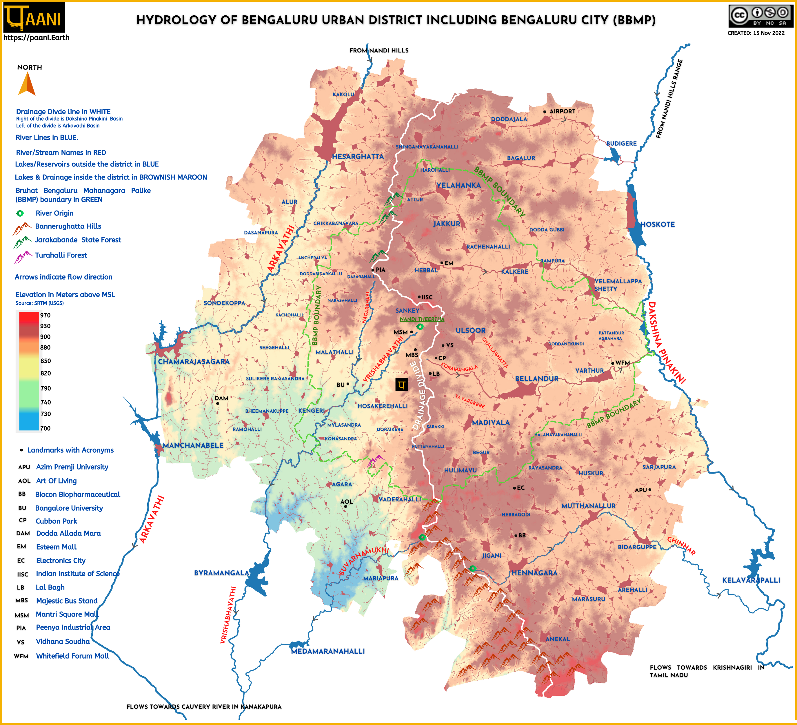
The infographic shows the surface hydrology-rivers, lakes, and raja kaluves (i.e., drainage) of Bengaluru urban spread over 2196 sq Kms, overlaid on its topography (Elevation data from Shuttle Radar Topography Mission (SRTM) of United States Geological Survey) . A prominent ridge runs through the center of Bengaluru, shown in the infographic as a drainage divide. To the west is the Arkavathi River Basin, forming 46% of the district. To the east is the Dakshina Pinakini River Basin, occupying 54% of the district.
Using the Survey of India (SOI) Toposheets of 1973, we mapped 855 lakes in the Bengaluru Urban district. Four hundred and thirty-five (435) lakes to the west of the drainage divide, flow into Arkavathi, Vrishabhavathi, and Suvarnamukhi rivers. Four hundred and twenty (420) lakes to the east of the divide (including the Chinnar River that drains most of Anekal Taluk) flow into Dakshina Pinakini river.
The infographic also shows Bruhat Bengaluru Mahanagara Palike (BBMP), the City Municipality spread over 709 sq kms is situated inside the Bengaluru Urban district. The lakes, raja kaluves, and the river/stream corridors inside BBMP are under BBMP custodianship with the exception of Bellandur & Varthur lakes which are under Bengaluru Development Authority (BDA).
The significance of ‘Hydrology of Bengaluru’?
Bengaluru city was once aptly known as the city of lakes. But today, lakes are vanishing due to encroachment and pollution. As a result, citizens have risen for the protection and conservation of lakes. So today, it is apt to say Bengaluru is the city of lake activists. Besides, the activism is not just limited to Bengaluru city (i.e., BBMP area) but has spread throughout the district. Therefore, a holistic district narrative on lakes and their connections to rivers is needed. As matter of fact, this understanding of hydrology is key if one is serious about mitigating urban floods and building a smart and resilient city.
Furthermore, the government reports are incorrectly recording the district’s water resources.
Consider the District Environment Plan prepared by the Office of Deputy Commissioner. The environmental planning is done without an accurate accounting of water resources in the district. While the river name ‘Arkavathi’ comes up only once in the document, the rest of the rivers are non-existent. How will we conserve and protect rivers if the government does not acknowledge their existence?
Unfortunately, the government documents that acknowledge the existence of rivers report inaccurate and misleading data.
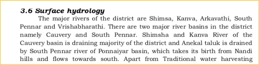
Take the District Irrigation Plan, developed under Pradhan Mantri Krishi Sinchayee Yojana (PMSKY). As shown in the excerpted image below, the report incorrectly says Shimsha and Kanva river flows through the district.
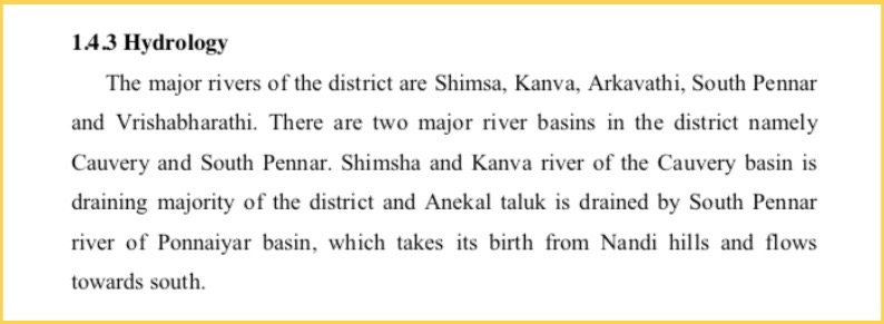
Even the Karnataka State Council for Science and Technology (KSCST), under the Indian Institute of Science (IISc), gets it wrong. In the report ‘Assessing the status of traditional water harvesting systems and measures for rejuvenation,’ KSCST says incorrectly that Shimsha and Kanva rivers flow through the district, as shown in the excerpted image below.
We need to get the facts right for proper planning and decision making.
Paani.Earth is licensed under a Creative Commons Attribution-NonCommercial-ShareAlike 4.0 International License

RIVERS

LAKES

POLLUTION

GROUNDWATER

DRINKING WATER

BIODIVERSITY

RAINFALL FLOODS & DROUGHT

