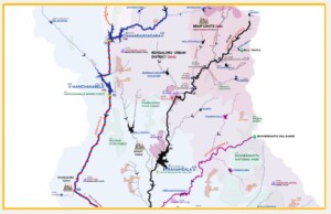
The Arkavathi river basin stressors map shows a wide range of human stressors affecting Arkavathi: Dams, Industrial clusters, Sewage treatment plants, Effluent treatment plants, Hazardous waste Landfills, Urban centers, Open-pit quarries, Hydropower plants, and polluted river stretches. It shows the proximity of quarries to major dam infrastructure. It shows back-to-back dams. This map is relevant to policymakers, lawyers, researchers, academicians, students, and citizens interested in conserving the Arkavathi river.
Click Image below to launch the map.
The map is fundamental to Arkavathi river rejuvenation efforts currently underway:
In the case of Original Application No. 673/2018, National Green Tribunal (NGT) ordered the state governments to restore the 351 river stretches identified by Central Pollution Control Board(CPCB) as polluted. Arkavathi’s fifty-one kms stretch from Chamarajasagar reservoir to Kanakapura town is one of the 351 stretches under restoration.
NGT, in its order, suggested the government produce river maps showing the polluted stretches, tributaries, drains, major towns, industrial estates, and the location of STPs/CETPs. Taking the tribunal’s cue and understanding the significance of the suggestion, we generated the pressures map for Arkavathi with all the data points mentioned in the order. We are now able to identify pollution sources.While rejuvenation efforts are underway, the government has yet to produce such maps. Meanwhile, we have shared the map and discussed our insights with Karnataka Pollution Control Board on strengthening the Arkavathi river restoration.
The 23 data points represented in the map are enumerated below for easy understanding:
1.Arkavathi begins her 170km long journey from Nandi Hills in Chikkballapur district, traverses through Bengaluru Rural, Bengaluru Urban, and Ramanagara Districts before joining Cauvery river, inside Cauvery Wildlife Sanctuary in Kanakapura Taluk, Ramanagara district.
2. The map shows the administrative boundaries of the four districts and two states within the catchment. The river basin extends over the states of Karnataka (96%) and Tamil Nadu (4 %), draining an area of 4150 sq kms, which is roughly the size of Mauritius. Within Karnataka, the river basin spans four districts – Chikkballapur (0.2%), Bengaluru Rural (21%), Bengaluru Urban (25%), and Ramanagara (50%).
It conveys the need to integrate man-made and natural river boundaries for effective river management and conservation. Administrative planning units are unsuitable as the river’s flow and pollution problems continue beyond administrative boundaries.
3. The Bengaluru city municipality – Bruhat Bengaluru Mahanagara Palike (BBMP), occupies roughly 6% of the basin. This 6% is a concrete jungle and, therefore, a significant source of pollution.
4. The origin-Nandi Hills, is at an elevation of 1478 meters. The confluence with Cauvery is at an elevation of 370 meters. The elevation drop from the origin to the confluence is 1108 meters.
5. Three major tributaries and their origins: Vrishabhavathi (69Kms) –Nandi Teertha Temple, Kumudvati (45Kms) – Shivagange hills, Suvarnamukhi – Bannerghatta hills
6. Other streams like Dodda Halla, Banda Halla, Kutle Hole, Rayamala hole, Muttiyalamma hole, Antarangange hole, and Chiktore are marked (Source: Indiawris).
7. Thirteen impoundments on the main Arkavathi river channel and their reservoir capacities are on the map. The major ones are Hesaraghatta (Custodian: BWSSB), Chamarajasagara(Custodian: BWSSB), Manchanabele(Custodian: CNNL) & Arkavathi (Custodian: CNNL).
8. The site of the proposed 64 TMC Mekedatu Dam on the Cauvery river inside Cauvery Wildlife Sanctuary.
9. The river basin has roughly 110 waterbodies managed by the Minor Irrigation Department, some of which are on the map: Byramangala, Nelligudda, Maralvadi, Doddaladahalli, Neeralhatti, Chikkagondanahalli, Ravuthanahalli, Thattekere, Muninagara, Vaderahalli, Agara, Belagumba, Beguru, Billanakote, Madhure, Doddatumukuru, Nagarakere, etc.
10. The irrigated area (Ultimate irrigation potential) of the three irrigation dams in the river basin – Arkavathi(15,000 acres), Byramangala (5510 acres), and Suvarnamukhi (area not known), are given. (Source: Cauvery Basin Report). Manchanabele Dam, although built for irrigation, is not serving the purpose, and thus, the irrigated area is not given. The dam water’s current use is drinking and fishing.
11. Marked river kilometers helps give specific data point. E.g.:
- At 76th Km is Chamarajasagar Dam and at 86th km is Manchanabele Dam, indicating that major dam infrastructures are built merely within 10kms. This back-to-back damming spells doom for the river and its wildlife.
- At 64th km is a huge toxic quarry waste dump leaching toxic pollutants into the river.
- At 61st km, the waste from Peenya Industrial Area joins the river.
12. Central Water Commission (CWC) monitors river flow at T.bekuppe and Kokkedoddi. Additionally, Flood forecasting is done at T.bekuppe site. (Source: Indiawris)
13. The map locates CWC’s Biligundla flow monitoring station on the Cauvery river. The flow data from this station is vital in sharing Cauvery water between Karnataka and Tamil Nadu.
14.The river basin has two hydropower plants under Karnataka Renewable Energy Development Limited (KREDL). Rising Sun Power ( 2 MW Installed Capacity) on Vrishabhavathi river, Sai Spurthi (10.25 MW Installed Capacity on Arkavathi). (Source: KREDL)
15. Karnataka State Pollution Control Board (KSPCB) monitors the Arkavathi river at 6 locations, whereas the Vrishabhavathi river at 13 locations. (Source: RTI)
16. Fourteen forests are identified using Survey of India toposheets, including major forests like Bannerghatta National Park and Cauvery Wildlife Sanctuary. All come under the purview of the Karnataka Forest Department (KFD).
17. In 2018, the Central Pollution Control Board (CPCB) identified approx 51 kms stretch of Arkavathi river from Chamarajasagar reservoir to Kanakapura town as a Priority III polluted river stretch (marked as red dots on the river)
Central Pollution Control Board identifies polluted river stretches based on Biological Oxygen Demand (BOD) ( a water quality parameter that indicates sewage pollution). Depending on BOD levels, the polluted stretch is into five priority classes, with Priority I being the most polluted and Priority V the least. Arkavathi river was Priority V in 2011. However, the pollution levels increased. Subsequently, in 2018, approx 51 kms stretch became Priority III.
A Glaring mistake:
Vrishabhavathi river, the carrier of Bengaluru’s waste ( Solid waste, liquid waste – sewage, and industrial effluents), is not identified as a polluted river stretch. Polluted river stretches are identified based on the Central Pollution Control Board’s monitored water quality locations. And the Central Pollution Control Board does not monitor Vrishabhavathi despite the BOD levels being >100 PPM all along the river.
If categorized, the Vrishabhavathi river would be a Priority I stretch.
18. Towns like Doddaballapura, Ramanagara, and Kanakapura, located on the banks of Arkavathi, are significant sources of pollution.
19. Four (4) sewage treatment plants: Vrishabhavathi Valley (330), Mailasandra (75), Kengeri (60), and Doddabele (60), owned by Bengaluru Water Supply & Sewerage Board (BWSSB ) in the BBMP area, has the installed capacity to treat 525 Million liters of sewage per day. Additionally, Ramanagara town has an installed capacity to treat 7.5 Million liters of sewage per day. Kanakapura has 6.2 Million liters of sewage treatment capacity per day. Ramnagara and Kanakapura, sewage treatment plants, come under Town Municipal Corporations (TMC) purview.
20. Central Ground Water Board (CGWB) assesses the stage of groundwater development/extraction by taluks and classifies it as Safe, Semi-Critical, Critical, and Overexploited (OE). Out of the ten taluks that fall in the catchment, seven are Overexploited, and three are Critical.
21. Open-pit quarry areas are identified from the Google Earth engine. They are close to major dam infrastructure – Chamarajasagara Dam, Manchanabele Dam, and Arkavathi Dam. The blasting activities of the mines can be a threat to the integrity of the dam structure. Additionally, toxic heavy metal waste from the mines can make its way into the river and the reservoir, polluting them.
22. Industrial areas are significant from a pollution perspective.
1. The Doddaballapura industrial area, located on the banks of Arkavathi, comes under the purview of the Karnataka Industrial Area Development Board (KIADB). It has two Common Industrial Effluent Treatment Plants (CETP).
Common industrial Effluent Treatment plants (CETP) are significant sources of pollution. They not only get toxic industrial effluents from various industries (textiles, bulk drugs, pharma, leachate from HW landfills) inside the river basin but also from outside the basin, increasing the pollution load significantly.
2. Peenya Industrial Area under Bruhat Bengaluru Mahanagara Palike (BBMP) is a Severely Polluted Industrial Area per Central Pollution Control Board. As shown in the map, a significant source of pollution, the Peenya industrial area drains into both Arkavathi and Vrishabhavathi rivers.
Hexavalent Chromium is a carcinogen and a reproductive toxicant found in dangerous quantities in Peenya’s groundwater. (This chemical gained notoriety from the Hollywood movie ‘Erin Brockovich’ played by Julia Roberts). Of the 66 borewells analysed in 2018, 31 borewells were contaminated with Hexavalent Chromium and were sealed. In 2013, 20 out of 72 borewells surveyed were contaminated with Hexavalent Chromium.
3. Dabaspete Industrial Area (includes Sompura) in the Kumudvati basin comes under the purview of the Karnataka Industrial Area Development Board (KIADB). It has a 93-acre hazardous waste landfill operated by Ramky Group. It also has a Common Industrial Effluent Treatment Plant (CETP), Bangalore Eco Park. Karnataka State Pollution Control Board (KSPCB) regulates the landfill and the CETP.
4. Kumbalgodu Industrial Area, situated on the banks of the Vrishabhavathi river, comes under the purview of the Karnataka Industrial Area Development Board (KIADB). It hosts texting dyeing & washing units, chemicals, pharma industries, and two common effluent treatment plants operated by Pai & Pai. Consequently, this industrial area is a significant source of pollution, as has been documented: Dev Kiran Paper Mills, Hazardous waste incinerator-Gomti Incinco, Plastic & E-waste recyclers, and more.
5. Bidadi Industrial Area, which houses large industries like Toyota-Kirloskar and Hindustan PepsiCo, is situated on the banks Vrishabhavathi river (Byramangala Tank), is under the purview of Karnataka Industrial Area Development Board(KIADB). While phase I was established in the 1990s, phase II was given environmental clearance in 2013.
6. Harohalli Industrial Area, also under the purview of Karnataka Industrial Area Development Board, is situated on the banks of the Suvarnamukhi river. It houses textile dyeing and washing industries, tire pyrolysis factories, oil re-processing units, paper mills, bulk drugs, pharma, etc. Additionally, the industrial area has two hazardous waste landfills operated by M/s Mother Earth Environ Tech Pvt Ltd(MEETPL). The landfill is a significant source of pollution among other industrial effluent discharges.
23. The various government bodies related to river water management are represented on the map:
- Cauvery Neeravari Nigama Limited(CNNL)
- Bengaluru Water Supply and Sewerage Board(BWSSB)
- Central Water Commission(CWC)
- Karnataka State Pollution Control Board(KSPCB),
- Minor Irrigation (MI)
- Central Ground Water Board (CGWB)
- Karnataka Renewable Energy Development Limited (KREDL)
- Karnataka Forest Department (KFD).
- Karnataka Industrial Area Development Board(KIADB).
- Karnataka Pollution Control Board (KSPCB)
- Central Pollution Control Board (CPCB)
- Bruhat Bengaluru Mahanagara Palike (BBMP)
- Town Municipal Corporations (TMC)
- Department of Mines and Geology (DMG)
Departments that are not marked but are part of water management in the basin:
- Zilla Panchayats
- Karnataka State Small Industries Development Corporation (KSSIDC)
- State Environmental Impact Assessment Authority (SEIAA)
- Judiciary – National Green Tribunal, High court, Supreme court
- Ministry of Environment, Forest and Climate Change (MOEF)
- Revenue Department
- Karnataka Tank Conservation and Development Authority (KTCDA)
- Command Area Development Authority (CADA)
These various government bodies collect data and do not share it. Such ingrained and deliberate practice of working in silos spells doom for the river. A platform that integrates the data points from these agencies at the river basin level is outside the public domain. A gap that we are working to fill.
CITATION: Paani.Earth. (2022). Arkavathi River Basin Map. https://paani.earth/arkavathi-river/
NOTES & REFERENCES:
- Geo-spatial data on administrative and forest boundaries is from Karnataka State Remote Sensing Application Centre’s (KSRSAC) Karnataka Geographic Information System (K-GIS).
- Survey of India Toposheets, Indiawris.gov.in, bhuvan.nrsc.gov.in along with google earth engine’s JRC Global Surface Water Mapping Layers are used to validate waterbodies data.
- Quarries have been mapped by us using google earth imagery and ground truthing.
- Karnataka Renewable Energy Development Limited (KREDL) website and ground truthing.
- Karnataka Pollution Control Board (KSPCB) website, Information via Right to Information and ground truthing.
- Central Pollution Control Board (CPCB) website.
- Bengaluru Water Supply and Sewerage Board (BWSSB) website and Information via Right to Information.
- Cauvery Neeravari Nigama Limited (CNNL) website and discussions with engineers.
- Minor Irrigation(MI) Department via Right to Information Act, ground truthing and discussion with the engineers.
- Central Water Commission(CWC) website and ground truthing.
- Central Ground Water Board (CGWB) website.
- Karnataka Industrial Area Development Board (KIADB) website and ground truthing.
- Datapoints were validated from Government submissions to National Green Tribunal’s in case OA 325/2015 and OA 673/2018.
- River basin hydrology, Waterbodies mapping, Rainfall, Population is from Google Earth Engine Catalog. The citations:
- Lehner, B., Verdin, K., Jarvis, A. (2008): New global hydrography derived from spaceborne elevation data. Eos, Transactions, AGU, 89(10): 93-94.
- Lehner, B., Grill G. (2013): Global river hydrography and network routing: baseline data and new approaches to study the world’s large river systems. Hydrological Processes, 27(15): 2171–2186. Data is available at www.hydrosheds.org.
- Funk, Chris, Pete Peterson, Martin Landsfeld, Diego Pedreros, James Verdin, Shraddhanand Shukla, Gregory Husak, James Rowland, Laura Harrison, Andrew Hoell & Joel Michaelsen. “”The climate hazards infrared precipitation with stations—a new environmental record for monitoring extremes””. Scientific Data 2, 150066. doi:10.1038/sdata.2015.66 2015.
- Center for International Earth Science Information Network – CIESIN – Columbia University. 2018. Gridded Population of the World, Version 4 (GPWv4): Population Count, Revision 11. Palisades, NY: NASA Socioeconomic Data and Applications Center (SEDAC). https://doi.org/10.7927/H4JW8BX5.
- Jean-Francois Pekel, Andrew Cottam, Noel Gorelick, Alan S. Belward, High-resolution mapping of global surface water and its long-term changes. Nature 540, 418-422 (2016).

RIVER BASIN

DAMS & FLOW

POLLUTION

GROUNDWATER

STRAWS

BIODIVERSITY

RAINFALL FLOODS & DROUGHT

RESTORATION

