Exploring Fragmentation of Open Water in Hesaraghatta Catchment
Updated Date: 08 Feb 2024
The lakes within the Hesaraghatta catchment underwent detailed analysis using Landsat imagery to identify and compare open water trends spanning three decades. Our scrutiny uncovered a significant fragmentation of open water within lakes in recent years, a phenomenon starkly absent in the 1990s.
This narrative contrasts two images taken 30 years apart to illustrate and explain the emergence of fragmentation of open water. Furthermore, our investigation delved deeper into the causes of this fragmentation through ground-truthing, consultation with locals, and engagement with Karnataka Forest Department (KFD), enriching our understanding of the underlying factors contributing to this very concerning trend.
Open water is the visible area of water in lakes or reservoirs that is detected and measured using satellite imagery. Clouds, trees, aquatic vegetation and buildings can obscure the detection of water by the satellite.
NASA’s Landsat satellite imagery data is used to detect open water. Landsat satellites have captured images of the Earth’s land surfaces since 1972, and all that data is available freely for analysis.
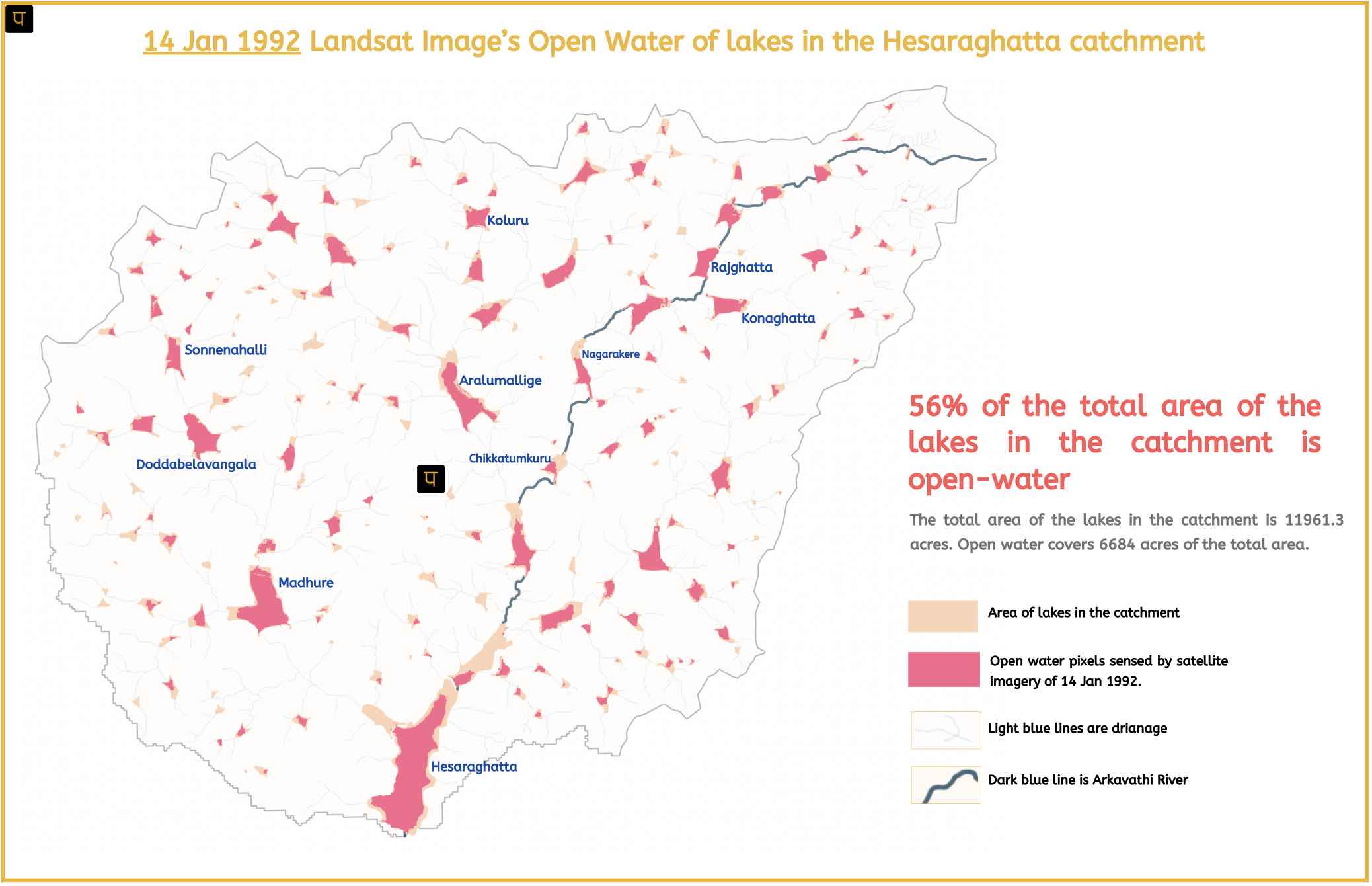
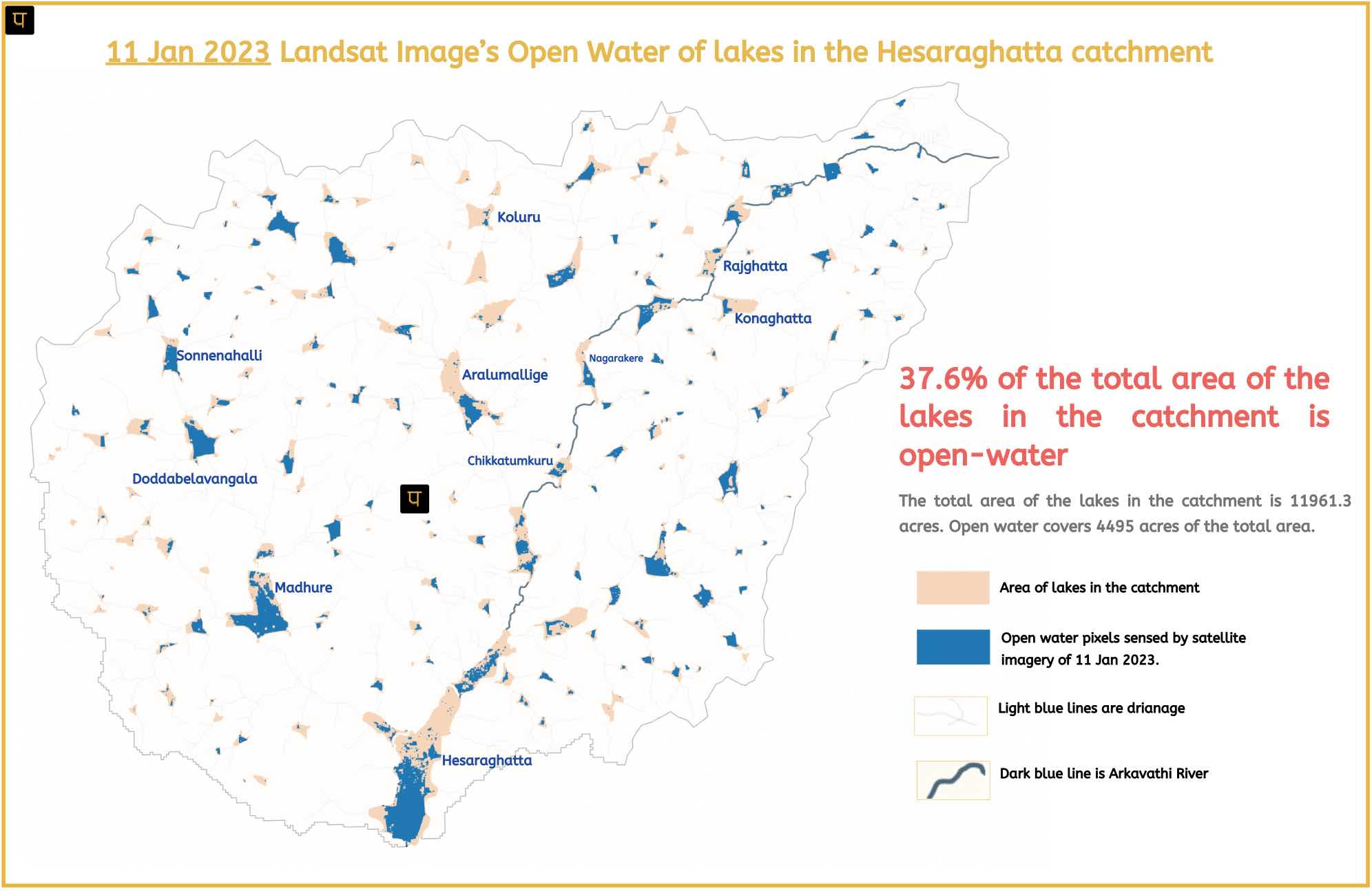
The Emergence of Open Water Fragmentation – Comparing Jan 1992 with Jan 2023 Imagery:
Jan 1992 shows a fuller water spread because of substantial precipitation in the preceding monsoon, i.e., the 1991 monsoon season.
In 1991, rainfall from June to December was 989mm, which is 52% above normal. This significant rainfall is the highest since 1975 and held the record until 2021.
As can be seen from the image to the left, the open water of 14 Jan 1992 satellite imagery is 56% of the total lake area.
The Jan 2023 image shows a patchy open water spread, unlike Jan 1992’s uniform water spread. In other words, the water spread is fragmented in the lakes.
The preceding monsoon (Jun-Dec), i.e. 2022, recorded 1263mm of rain, a 94% deviation from normal. This broke all previous records, including the one from 1991, making it the highest rainfall in 122 years.
Additionally, 2021 also experienced record-breaking rainfall of 1118mm, which is a 72% deviation from normal, making it the second-highest in 121 years, after 1903.
As can be seen from the image to the right, the open water of 11 Jan 2023 satellite imagery is 37.6% of the total lake area.
This unprecedented rainfall should have shown a fuller and more uniform water spread. Why the fragmentation?
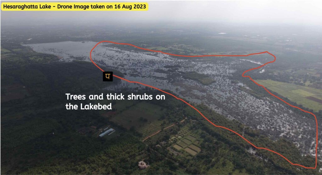
The fragmentation is attributed to the presence of trees on the lakebed, which obstructs the satellite view and prevents data collection for the areas under the trees. Additionally, aquatic vegetation like Water Hyacinth and Azolla also obstruct satellite views. We have observed aquatic vegetation in some lakes like Doddaballapura Nagarakere, Konaghatta and Chikkatumukuru, all of which receive raw wastewater from the Doddaballapura town, Doddaballapura industrial area and the surrounding settlements.
An inquiry into the presence of trees on lake beds uncovered that the Karnataka Forest Department has been cultivating commercial fuel-wood species for several decades.
Supposedly, the government implemented this measure to deter encroachment on the lakebed. However, this action presents a paradoxical situation where the government itself is encroaching on the land it seeks to protect from encroachment.
Consequently, this change in land use from lake to wooded plantation has significant implications for surface water storage, aquatic biodiversity, and hydrology.

RIVER BASIN

DAMS & FLOW

POLLUTION

GROUNDWATER

STRAWS

BIODIVERSITY

RAINFALL FLOODS & DROUGHT

RESTORATION


